Day Trips: Coyote Gulch offers a ‘spectacular’ canyon hike
Some of the most spectacular canyons I have ever visited are located in and around the Escalante River in Utah.
Many require technical skills to access but a few can be done as fairly easy backpacks. Coyote Gulch is a good place to start if you are interested in becoming familiar with this area.
The hike begins in Grand Staircase-Escalante National Monument but is primarily within Glen Canyon National Recreation Area.
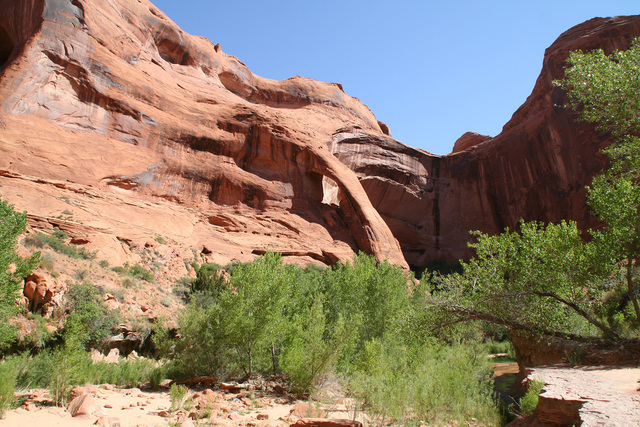
Although this outing will be about 25 miles round-trip, it’s easy hiking, except for a couple of areas, where you’ll need to do some rock scrambling. The highlights of the journey are its high canyon sandstone walls, a natural bridge, several arches, pools of water, and cascades, all within a riparian setting complete with hanging gardens. The trailhead elevation is about 4,560 feet and you will lose about 850 feet over the one-way distance to the confluence with the Escalante River.
I know of four ways to access the gulch, but through trial and error I have found the Hurricane Wash trailhead works the best. The first five miles are along a usually dry, sandy wash fully exposed to the sun. This stretch will test your patience, especially on the return trip.
At the end of Hurricane Wash you will go right into Coyote Gulch and the real fun starts. Here you will be walking in the stream, quite a pleasant experience as in most areas it is free of rocks and sandy. Unless there has been lots of rain before your visit, it is usually less than ankle-deep this time of year.
Less than two miles after entering the gulch you will reach Jacob Hamblin Arch. The arch spans about 100 feet within a giant fin of Navajo sandstone. The route follows the stream as it flows around the formation and on the other side you will find a natural spring tucked within the vegetation on your left side.
Continuing down the canyon about two miles you will come to Coyote Natural Bridge where you just walk on through the 100-foot opening and about two more miles after this you will come to Cliff Arch, whose shape suggests the handle of a jug.
Once you reach the mouth of Coyote Gulch you will be at the Escalante River, where you will get to see one of the best treats this hike offers. Stephens Arch is one of the largest in Canyon Country, spanning about 250 feet, and standing 600 feet above the stream course. Someone I met while at an alternate trailhead for Coyote Gulch, and one of the best viewpoints for this arch, told me that years ago a pilot flew a small airplane through it.
Allow at least three nights for this trip in order to explore all the canyon’s attributes. Right now through early November are ideal times to visit.
The major caveat to this hike is that it’s extremely popular. Be sure to visit midweek, and get on the trail as early as possible, so you’ll finish the day’s hike before others and thus have your pick of campsites. I have found that setting up a base camp a ways south of Jacob Hamblin Arch, and then exploring downstream without all your heavy gear, works best. Don’t set up camp too near the popular formations such as the arches and bridges, as they tend to get congested and will offer no solitude.
Campsites should be at least 100 feet, 200 feet preferably, from water sources. No camping is allowed near archaeological or historical sites. Fires are not allowed anywhere, so you’ll need to carry a backpacking stove if you heat your food. Treat or filter the river water before drinking.
A free backcountry permit is required for this trip and can be obtained at the Escalante Interagency Visitor Center, 755 W. Main St. in Escalante. You also have the option to self-permit 0.2 miles down the hiking route from the Hurricane Trailhead.
Flash flooding is a major concern in all narrow canyons such as this one. Be aware that flash flooding can happen any month of the year and many people have died in this area because they were not prepared.
So, even if you decide to self-permit, be sure to stop at the visitor center for weather updates and other pertinent information that might affect your hike. Also, be sure to check on the condition of the gravel Hole-in-the-Rock Road, which is very rough and subject to washouts. A four-wheel-drive vehicle is sometimes necessary.
Deborah Wall is the author of “Base Camp Las Vegas, Hiking the Southwestern States,” “Great Hikes, A Cerca Country Guide,” and co-author of “Access For All, Touring the Southwest with Limited Mobility.” Wall can be reached at Deborabus@aol.com.
- Directions from Pahrump: take NV-160 south for about 52 miles to Las Vegas.
- Merge onto I-15 north and drive for about 135 miles (passing through Arizona) to Utah Route 9 (Exit 16- Hurricane/Zion National Park).
- Follow Route 9 for 57 miles through Zion National Park and turn left onto U.S. 89 north.
- Take Utah Route 89 for 44 miles to a right onto Utah Route 12.
- Follow 60 miles to the town of Escalante. Drive east on Route 12 for five more miles, then turn right onto the well-marked Hole-in-the-Rock Road.
- Drive 33 miles to Hurricane Wash Trailhead on left, parking area is on right.


