A distinct weather phenomenon was witnessed above the Pahrump Valley on Wednesday of this week.
National Weather Service Meteorologist Jenn Varian said that a local resident sent in a photo of what initially appeared to be a tornado, near Blagg Road and Irene Street.
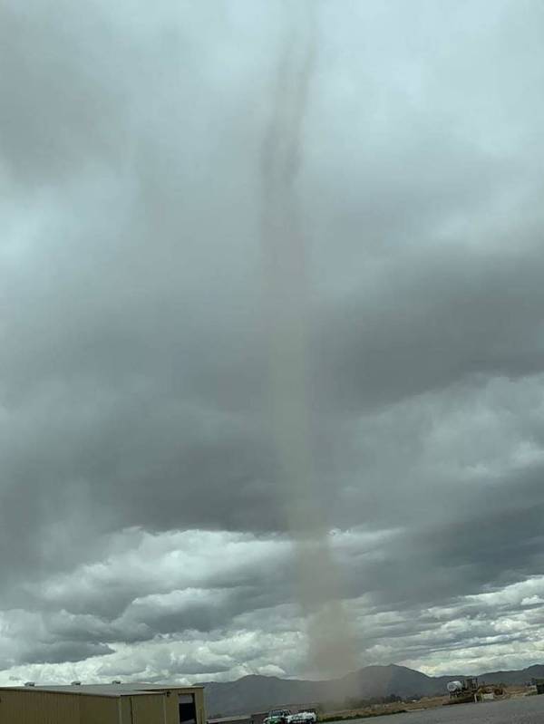
“The first photo that we received looked like a funnel cloud,” Varian said in a telephone interview from Las Vegas. “The difference between a funnel cloud and a tornado is that they both originate from the cloud base, but a tornado reaches the ground, whereas a funnel cloud does not reach the ground.”
Varian also said she began receiving actual reports and additional photos of the weather system beginning at roughly 12:30 p.m. on Wednesday.
“It looked as though it extended from the cloud base but it wasn’t touching the ground,” she said. “On the next photo that we received, it was touching the ground and it was a little brown in color, but we weren’t sure if it was exactly extending up to the cloud base or not. We discussed whether it was perhaps a dust devil.”
Assessing damages
Varian noted that Pahrump Fire Chief Scott Lewis was contacted about the incident to learn whether the system caused any damage.
“Apparently there is some construction going on that’s kicking up a lot of dust and apparently there have been quite a few dust devils this week, because it has been fairly windy,” she said. “We’ve had reports of dust devils all week so we thought it was likely a dust devil in the photograph. Chief Lewis went around to determine if there was any debris or any sort of damage as a result, but there wasn’t any.”
Later in the evening on Wednesday, Varian said weather service officials actually received additional photos, as well as video images of the funnel cloud at around 8 p.m.
“It became more clear to us that it looked like it extended from the cloud base, therefore it would not qualify as a dust devil,” she said. “It would either be a tornado or a funnel cloud, but we also have photos of it hitting the ground and kicking up dust. We concluded that it was a landspout tornado, which qualifies as an EF-0. The reason that it’s a landspout is because it did not extend to the cumulonimbus clouds, but rather kind of like a junior storm cloud.”
Cumulonimbus clouds, Varian noted, are dense, towering vertical clouds, forming from water vapor carried by powerful upward air currents.
“From my understanding, these funnel clouds or landspouts are fairly uncommon in Southern Nevada, but it’s very rare,” she said. “It’s happened before but it’s not something we see frequently here in Southern Nevada.”
Regarding the Memorial Day weekend weather forecast, Varian said Pahrump residents can expect unseasonably cooler temperatures, with possible precipitation.
“This weekend Pahrump will have a 20 to 30 percent chance of rain, and isolated lightning is also possible,” she said. “Through the weekend, we are looking at another system coming in somewhere around Sunday morning. Temperatures will also remain below average throughout the weekend. Right now we are hovering at around 20 degrees below average temperature for this time of year. The temperatures will increase a little bit over the weekend but it will still be below average.”
Contact reporter Selwyn Harris at sharris@pvtimes.com. On Twitter: @pvtimes