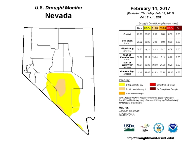
Almost all of Nye County is in an extremely dry area when compared to the rest of the state, the latest data from the Western Regional Climate Center shows.
According to the map released by the center on Feb. 7, most of county falls under abnormally dry areas. Several areas that cover Tonopah and area west of Beatty fall under moderate drought.
The abnormally dry area covers most of Nye County, and parts of Esmeralda, Lincoln and Clark counties.
The population in drought areas is estimated at 7,642 people, according to the Western Regional Climate Center.
David Simeral, associate research scientist in climatology at Desert Research Institute in Reno, said the precipitation for areas that fall under moderate drought has been between 50 percent and 90 percent of normal.
“That area has been getting 50 percent of the normal rain amount for the last 90 days,” Simeral said.
In addition, the area covered by moderate drought also has below normal soil moisture level.
“If we aren’t getting as much rain, then soil moisture is impacted,” Simeral said.
Countywide, the precipitation is 4 inches below normal for the past 12 months.
Although Tonopah has been getting a lot of snow this winter, Simeral said it didn’t affect the overall drought conditions in the area.
“They may be getting some snowfall, but they are still below normal for the year,” he said.
The map takes into account weather over the past week, but also over the last couple of years.
“Drought is a slow-moving natural disaster, so its onset takes a long time, and getting out of drought takes extensive time as well,” Simeral said.
“Overall, we’ve seen significant improvement all over the state in terms of drought conditions,” Simeral said.
Nevada State Engineer Jason King said none of the state is in the area of severe or greater drought. King called it “a good thing.”
“You can see that there is no significant drought being felt in the entire state, including Nye County,” King said.
While the drought conditions are updated every week on the map, Simeral said sometimes it can be challenging to obtain the data because of the low density of weather stations across Nevada and difficulties in obtaining drought impact information.
“We do work with agencies such as the Bureau of Land Management, UNLV Cooperative Extension, Natural Resources Conservation Service and the National Weather Service, but it’s a big state and it can be challenging because of the mountainous terrain and because of the low density of weather stations,” Simeral said.
The Western Regional Climate Center is one of six regional climate centers in the U.S. Its mission, according to the website, is to act as a repository of historical climate data and information and disseminate high-quality climate data and information pertaining to the Western U.S.
Contact reporter Daria Sokolova at dsokolova@pvtimes.com. On Twitter: @dariasokolova77