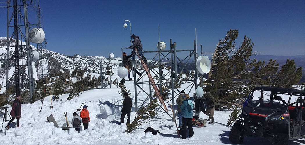
Nevada’s mountaintop camera network tracks western wildfires
Mountaintop cameras spotted or tracked 240 fires in Nevada and California in 2017.
The cameras from the University of Nevada, Reno helped to keep firefighters more situationally aware and able to mount appropriate responses more rapidly over tens of thousands of square miles of forests and rangelands, including rural communities.
This is a new and expanding tool for fire managers who oversee the wildland and wildland/urban interface.
“The success of our system lies in our ability to deploy wireless, microwave technology to enable high-speed internet out in the wilderness,” Graham Kent, director of the Seismological Laboratory Lab in the College of Science, said. “We call it the Internet of ‘Wild’ Things or wilderness Internet.”
The high-definition near-infrared night-capable fire cameras are part of the AlertWildfire network, conceived, developed and implemented at the Nevada Seismological Lab. The network has grown from the AlertTahoe system that began with a three-camera pilot project at Lake Tahoe in 2015 to four networks with more than 55 cameras.
The cameras cover areas of Nevada and California’s Sierra Nevada, and includes San Diego County and Santa Barbara with an eye to Oregon and Idaho coming online soon, with several more states making inquiries.
“Clearly, more systems are needed throughout the west,” Kent said. “I’m happy with the AlertTahoe and BLM Wildland systems as prototypes – but there are plenty of other areas that are in dire need of this technology.”
Kent and his team, along with colleague Neal Driscoll at University of California, San Diego, have their eye on northern California, the Sonoma/Napa area, which was devastated by fire in 2017, and hope to start this spring on building capacity there. Fire camera sites in southern Idaho and Oregon are also funded as Kent, and College of Science partner Ken Smith, work with Doug Toomey at the University of Oregon to move northward in 2018.
“It’s not too late for the North Bay – or an AlertNorthBay – as well over 80 percent of the region remains unburned; and much of the 20 percent that burned could burn again with large swaths near the Tubbs, Atlas and Nuns Fires, which haven’t burned in 150 years,” Kent said. “It’s scary.”
“All this must change if we are going to respond to fires in the urban-wildland interface, or fires after an earthquake,” he said. “With one of the driest years on record, following the wettest year (2017) – it’s a dangerous cocktail for 2018. Big timber fires such as the Rim and King fires may be a consequence of this unusual weather pattern.”
A nearly 3,000-acre fire near Bishop, California in mid-February may be a harbinger for what is ahead in 2018. With this in mind, the university groups are scrambling to get as many cameras into the wilderness as possible before fire season 2018 peaks.
Fire monitoring marries seismic monitoring
The prototype AlertWildfire system uses the backbone of the Nevada Seismo Lab’s earthquake monitoring network, with its 200 seismograph stations in Nevada and eastern California, leveraging technology for public safety with the high-tech mountaintop cameras linked into the network.
Fire managers can manually rotate, tilt, pan and zoom the cameras. YouTube channel, nvseismolab, has a library of videos captured from the network.
Fires in 2016 highlighted the need for an auto-detect capability that will alert fire managers to new fires. In 2017, Kent brought another partner into the system, IT for Nature from Poland, providing machine vision auto-detect and learning – software that can detect the first signs of smoke – which has been successful where implemented.
“The cameras have to be monitored for them to be most effective,” Kent said. “The on-demand time-lapse video we produce is a useful first step, but we’re excited for the auto-detect software to capture critical intel even earlier,” Kent said. “Basically, a 911 cell phone call typically beats the machine vision, but not by much, so we anticipate in the next couple of years, the machine might get a bit faster,” Kent said. “Or better yet, we’ll build outreach programs to crowdsource the cameras, which will likely always be the fastest.”
Humans versus machines
Crowdsourcing, an army of volunteers on the cameras over time – especially times where fire danger is grave – if appropriately implemented, could beat out the “machines” until technology improves.
“That will likely be the fastest path to discovery, with machine vision as a viable backup,” he said. “But over time, we anticipate that many fires will be first detected by ‘machine’ and not humans.”
UNR is in a lead position nationwide in developing the inexpensive, multi-use, high-throughput, research-grade internet protocol networks and expanding their use for all-hazard monitoring.
The AlertWildfire networks use and augment the Seismo Lab’s earthquake monitoring network that crisscrosses the third most seismically active state in the nation, turning the seismograph recording sites into hazard monitoring networks able to track fires, floods, hazardous weather such as ArkStorms and landslides. The Seismo Lab even installed a camera in Washington State to monitor a potential landslide area and has two cameras at the Oroville Dam in California to monitor work and environment of the dam’s damaged spillway.
“With our private, high-speed internet communications network in place, these sites also easily adapt to earthquake early warning detection systems that can provide public notification of expected, potentially damaging ground shaking,” Kent said. “The system could be the backbone for a more resilient earthquake early warning system as the current ShakeAlert buildout is heavily leveraged on cellular technology.”
“The multi-hazard approach actually helps us to build the best seismic network in the U.S.,” Kent said, “as we tend to build in a lot of resilience for the fire cameras because you know you’ll have fires all the time so the network better work each and every day – all day and all night. So ironically, expansion into fire has made us a very big player in the seismic arena.”
“The AlertWildfire networks epitomize our goal for community outreach,” Jeff Thompson, dean of the College of Science, said. “The Seismological Lab is inherently service to community, providing important alerts to the public, government agencies and emergency managers. The addition of the AlertWildfire systems is a natural evolution of what our group is all about. Graham and his team have worked hard to make this happen, and it’s no wonder they’ve been successful.”


