Alabama Hills a favorite backdrop for outdoors enthusiasts and Hollywood


The 30,000-acre Alabama Hills Recreation Area, sprawled at the base of the lofty Sierra Nevada just outside Lone Pine, California is an especially picturesque piece of the West, yet uncrowded and easily accessible in a weekend trip from Pahrump.
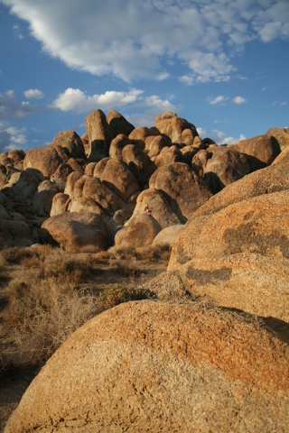
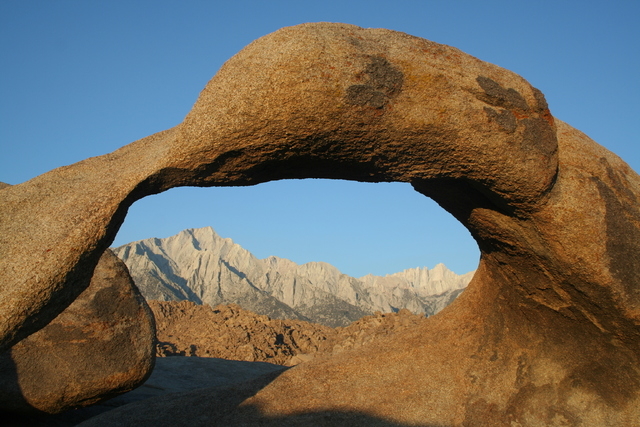
Formed millions of years ago by geologic faulting, the open landscape is festooned with granite boulders in all sizes and shapes, and other unique formations such as arches.
It’s so picturesque, in fact, that the area has been a favorite filming location for more than 90 years, lending its beauty to hundreds of movies, television programs and commercials.
En route to the hills, movie buffs, especially, should stop in Lone Pine to grab a movie location map. They are available at various locations including at the Eastern Sierra Interagency Visitor Center, located at the intersection of U.S. Highway 395 and California Route 136 on your way into town, and the Lone Pine Chamber of Commerce on the main drag.
Once in the Alabama Hills you might recognize scenery from 1948’s “Yellow Sky” with Gregory Peck and Anne Baxter, or 1936’s “Charge of the Light Brigade” with Errol Flynn and Olivia de Havilland. There are several sites used for the 1939 filming of “Gunga Din” starring Cary Grant and Douglas Fairbanks Jr. The latter production was such a large one that they had to build a tent city to house much of the cast and crew.
More recent films using the Lone Pine area include 1990’s “Tremors,” starring Kevin Bacon; 2000’s “Gladiator,” starring Russell Crowe; and 2008’s “Iron Man,” starring Robert Downey Jr.
The easiest way to access the area is just a few miles west of Lone Pine along Whitney Portal Road. Here you will find Movie Road on your right, a good place to begin your visit whether exploring by car, by mountain bike, or on foot. Hiking possibilities are endless, although it’s fun to simply poke around the myriad of jumbled boulders or sit atop one and gaze up at the high peaks that lie immediately west.
While all the formations are interesting, there are a few that really stand out, including some natural arches. One of the best in the area can be found by taking the Alabama Hills Arch Nature Trail. The trail was created in partnership with the Eastern Sierra Interpretive Association and the Alabama Hills Stewardship Group.
To reach the trailhead starting from the intersection of Whitney Portal Road, drive 1.5 miles northwest on Movie Road. Go right at the obvious fork and you will find the parking area immediately on your left. You will see the trailhead on the left side of the parking area. The trail has undulating terrain but it is an easy hike taking less than 15 minutes round-trip.
If you have an extra hour or so, it is well worth driving up the 13-mile Whitney Portal Road itself. At its end you will be at an elevation of more than 8,300 feet. There you’ll see a small trout fishing pond and a stunning stream, complete with cascades and waterfalls, all set in a heavily forested area.
Here also is the trailhead for a hiking route up 14,496-foot Mt. Whitney, highest peak in the lower 48 states. At 10.7 miles it’s the least strenuous route, but still challenging. It’s so popular you must secure a permit to hike it. Even so, you will find throngs of people doing the same thing.
To learn more about movies filmed in the Alabama Hills and surrounding area, your best bet is visiting the Beverly and Jim Rogers Museum of Lone Pine Film History. The museum houses an excellent collection of film memorabilia including cars, stagecoaches, costumes and historic photographs. The museum is located on 701 S. Main Street, Lone Pine.
The Alabama Hills’ name, by the way, predated the colorful filmmaking era. The hills were named during the Civil War by southern sympathizers mining in the area, in honor of the Confederate warship, CSS Alabama.
The recreation area is open year-round yet some portions are closed during filming. The main roads are gravel but well graded, so most vehicles won’t have a problem. Some of the spur roads, though, can be quite rough for any vehicle. The Whitney Portal Road is paved but its upper reaches are closed in winter due to heavy snow.
Deborah Wall is the author of “Base Camp Las Vegas, Hiking the Southwestern States,” “Great Hikes, A Cerca Country Guide,” and co-author of “Access For All, Touring the Southwest with Limited Mobility.” Wall can be reached at Deborabus@aol.com.