Daytrips: Canyonlands one of the most significant rock art sites in North America
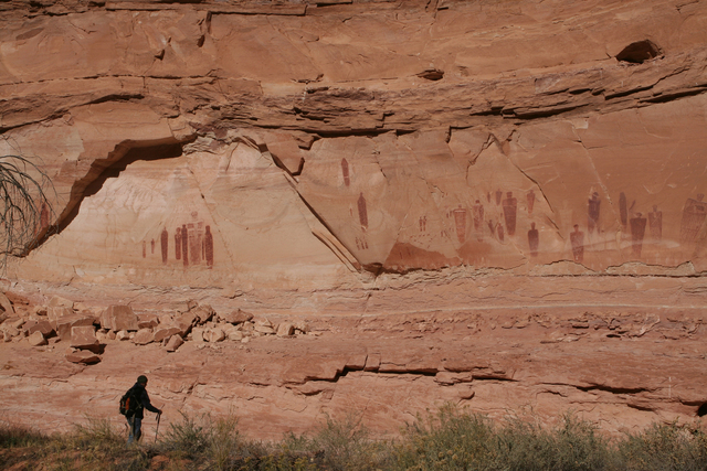
The Great Gallery in Horseshoe Canyon is one of the most significant rock art sites in North America.
It is located in a remote area of Canyonlands National Park, Utah. A trip here requires plenty of preparation, plus the equipment and willingness to drive a 30-mile gravel road to the trailhead. Once there you’ll need to hike down through the slick rock which contains a few places with high drop-offs into the canyon. It is a moderately strenuous hike of about 6.5 miles round-trip with an elevation loss/gain of about 800 feet at the beginning and that much to climb back up at hike’s end.
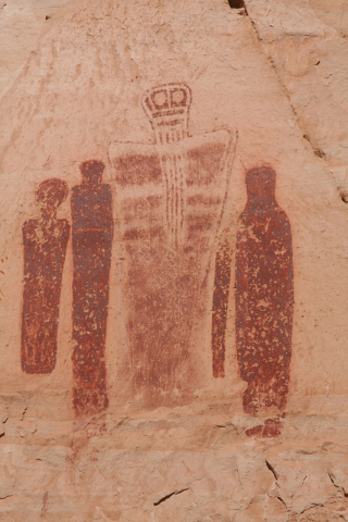
The rewards are tremendous, though. The Great Gallery is one of the highlights of this section of the park and features life-size anthropomorphic figures painted on the cliff walls in the Barrier Canyon Style. You will be able to see dozens of pictographs but those which have an ethereal appearance, many suggesting human depictions of aliens, are quite extraordinary to see.
October is an excellent time to visit, for the hundred-plus temperatures of summer have given way to more pleasant conditions. But remember, the weather is unpredictable here at 5,350 feet in elevation. The first time I visited many years ago it was late October, and we camped at the trailhead. When we woke the next morning at dawn the temperature was only 19 degrees.
Bring water and more than you expect to need, as there are no reliable sources at the trailhead or in the canyon. I highly recommend traveling to the trailhead in a four-wheel drive, high-clearance vehicle with good off-road tires. Many spots have deep sand and there are some rocky sections as you near the trailhead. If it rains, don’t travel the roads for they become impassable. And by all means postpone the hike if rain is expected or even threatened because flash floods in this canyon could be deadly.
While much of Canyonlands National Park is accessed from points just outside of Moab, Utah, it takes 2-1/2 hours to get from Moab to the Horseshoe Canyon trailhead. If you aren’t staying in Moab and coming from Las Vegas it will be a lot quicker as per directions below.
From the trailhead, head down into the sandstone and follow the route using the well-placed cairns that guide you. Once you are off the sandstone and have dropped into the canyon proper, go right and head upstream. After about one-third mile, look on your left for a well-worn path that heads toward the cliffs. On the cliff walls, behind screening vegetation, you will find the first set of pictographs known as the High Gallery. Continue upstream and the rest of the sites will be found on your right; they’re fairly easy to spot. They go in order from Horseshoe Shelter, Alcove Site and then the best of all, the Great Gallery.
Conventional wisdom formerly held that most of these panels were very old, as much as 8,000 years. Recently a team of scientists from Utah State University has concluded that the rock art was done no more than 2,000 years ago. The jury is still out, though, as other experts remain steadfast that they are older than that.
No matter how old they might be, they are fascinating to see. I have visited hundreds of rock art sites in the Southwest and this by far is one of the most unusual I have ever seen.
Camping is not allowed in Horseshoe Canyon itself but is permitted on the BLM land at the trailhead. There are no assigned spots, picnic tables or fire pits, just open camping. For more information on this area and road conditions contact the Hans Ranger Station at (435) 259-2652 or www.nps.gov/cany.
Deborah Wall is the author of “Base Camp Las Vegas, Hiking the Southwestern States,” “Great Hikes, A Cerca Country Guide,” and co-author of “Access For All, Touring the Southwest with Limited Mobility.” Wall can be reached at Deborabus@aol.com.
Directions from Pahrump:
- Take NV-160 south for about 52 miles to Las Vegas.
- Merge onto I-15 north and drive for 250 miles to I-70.
- Go east and drive about 149 miles and go right to UT-24 west.
- Follow about 24 miles and go left on the signed Horseshoe Road (just south of Goblin Valley State Park).
- Drive about 30 miles, staying left at the obvious fork in the road.
- The right fork leads to the remote Hans Ranger Station in the Maze District.


