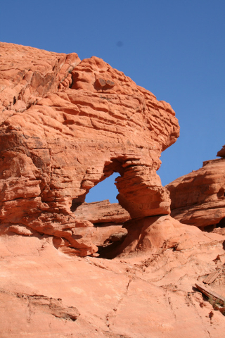
Day Trips: Formations, vibrant colors greet hikers at Bowl of Fire
Ask any local nature lover if he or she has visited The Bowl of Fire, and the answer will usually be “Of course!” But a great many of those answers are incorrect because people confuse it with the similarly named Valley of Fire State Park.
While both are must-sees for anyone who can do both, and involve similar terrain, The Bowl of Fire is a completely different experience because it is accessible only by hiking. That means on most days you’ll likely have the place to yourself. And you’ll always have the satisfaction of knowing you got there on your own two feet and willpower.
The Bowl of Fire lies in a remote area off Northshore Road in the Lake Mead National Recreation Area.
Elevation at the trailhead is 1,933 feet, and from the parking area to the Bowl of Fire itself it is a moderate 2.25 miles, with minimum elevation gain. From the parking area, head northwest toward the prominent limestone ridge. There is only a faint unmarked trail here, so you will have to do some route finding. On the north side of the ridge you will most likely find a somewhat more obvious path; just follow that path west. Once around this small formation you will be able to see the red rock sandstone outcropping – The Bowl of Fire, which will be your destination.
As you head west you will cross the rough, gravel Callville Wash North Road. This is a lawful motorized route into the area, but should be attempted only in four-wheel-drive vehicles with good off-road tires. Also designated by the Lake Mead NRA as “Approved Backcountry Road 94,” its entrance lies near mile marker 16 of Northshore Road.
Once you cross the gravel road, head toward the outcropping. You will have to drop into the main drainage wash here and walk upstream. After a hundred yards or so, all easy progress will be blocked, but with a short rock scramble you are up and have arrived at Bowl of Fire.
The route you take to explore the area is up to you. You will find small arches, windows, overhangs and holes in the sandstone. In the very distant past, these rocks were sand dunes. Over time they turned to stone and were shaped by complex uplifting, faulting and erosion. The vibrant red and orange coloring results from oxidized iron in the rock.
There are many places in the outcropping where you can easily climb and take in views of the surrounding landscape. Be careful where you place your feet and hands, though, as rattlesnakes are out and about this time of year. A few years ago, I ran into a Mojave green rattlesnake up close, while in the park, one of the most venomous snakes in the United States.
Directions from Pahrump:
- Take NV-160 south about 52 miles to Las Vegas.
- Merge onto I-215 east and drive about 12 miles.
- Continue straight for Lake Mead Drive in Henderson.
- Go east for about 10 miles to Lake Mead National Recreation Area’s entrance station.
- Drive 0.3 miles and go left onto Northshore Road. Follow for 18.2 miles.
- Just after mile marker 18, look for parking pullout on left side of road, which serves as the trailhead.
Deborah Wall is the author of “Base Camp Las Vegas, Hiking the Southwestern States,” “Great Hikes, A Cerca Country Guide,” and co-author of “Access For All, Touring the Southwest with Limited Mobility.” Wall can be reached at Deborabus@aol.com.


